
Dieppe, New Brunswick--(Newsfile Corp. - August 25, 2022) - Colibri Resource Corporation (TSXV: CBI) (OTC Pink: CRUCF) ("Colibri" or the "Company") is pleased to report assay results from the second half of its Phase 1 drill program completed on the Evelyn property located in the Caborca Gold Belt, northwestern Sonora. The second half of the Phase 1 drill program was initiated in February 2022, was completed in May 2022, and included 3,101 metres ("m") of reverse circulation ("RC") drilling completed in 22 holes. In total, Phase 1 drilling on the Evelyn property includes 6,223 m of RC drilling completed in 42 holes.
The objective of Phase 1 drilling on the Evelyn property has been to test three primary surface showings at the Cerro Rojo, El Sahuaro, and the West Zones which have been derived from mapping and trenching completed over previous exploration programs.
New results include an intersection of 0.165 grams per tonne Au (g/t Au) over an intersection length of 86 m which includes 22 m at an average grade of 0.316 g/t Au in hole EVE22-042 from the Main Zone. Combined with other newly drilled intercepts from Main Zone drilling, previously released drill and surface sampling results, and evaluation of geophysical data sets, the Main Zone remains a high priority target on the Evelyn property for the discovery of an orogenic gold deposit.
The Main Zone is located within the Cerro Rojo target area and has been the subject of historical small-scale mining along a high-grade vein which Colibri has sampled at surface and includes a value of 43.9 g/t Au.
Significant assay results from the second half of the Phase 1 drill program are illustrated on the map of the property in Figure 1 and are tabulated in Table 1 below.
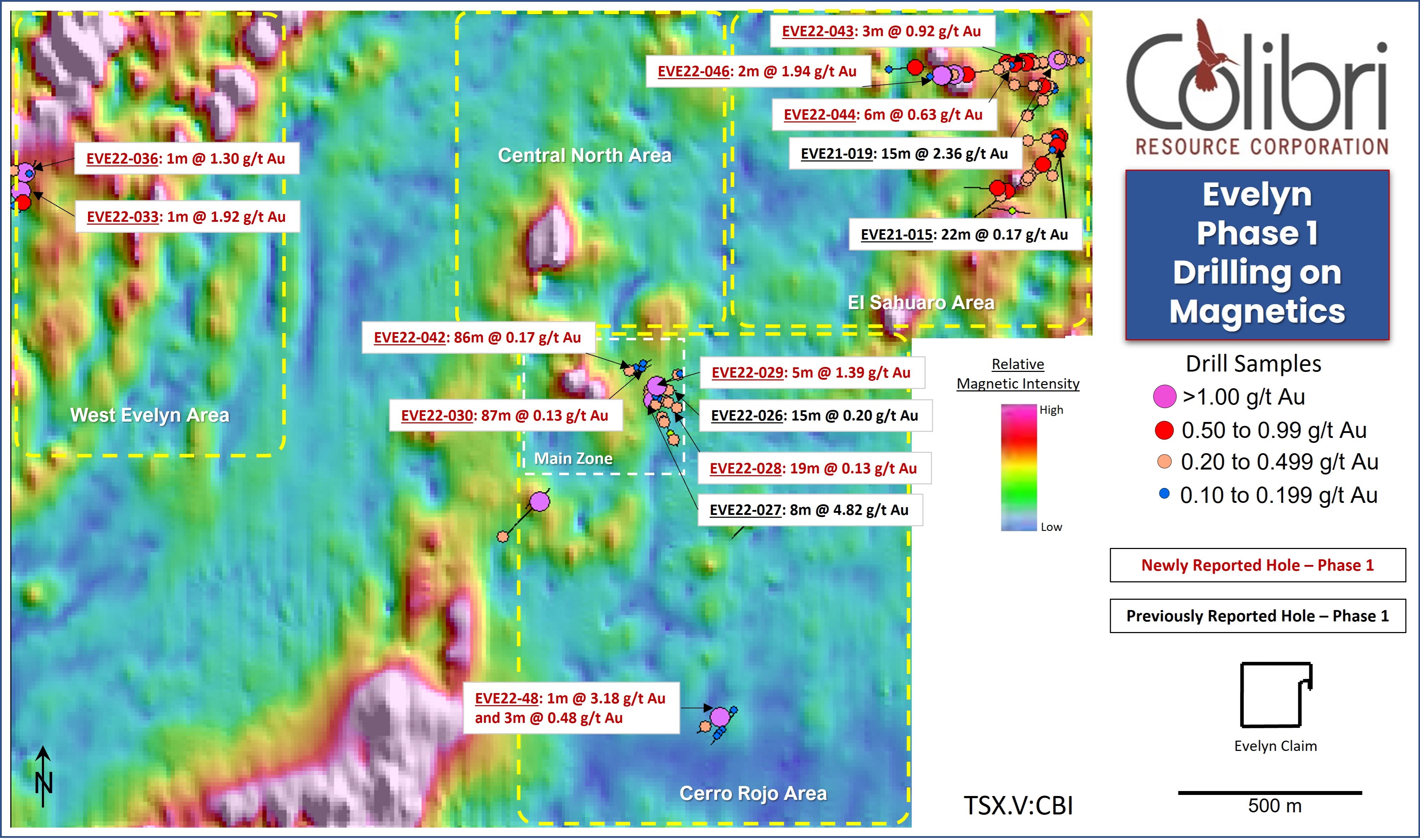
Figure 1 -Evelyn Phase 1 Drilling - Highlighted Results
To view an enhanced version of this graphic, please visit:
https://images.newsfilecorp.com/files/4269/134831_02868331e4e7992b_001full.jpg
In addition to drilling during the period, the Company continued geological mapping on the Property and also collected and analyzed additional soil samples infilling historical property wide soil surveys. The results of the assays recently completed as well as exploration completed on the property are discussed below including plans for Phase 2 drilling and continued exploration on the property.
Ron Goguen, President & CEO of Colibri commented, "Our Phase 1 drilling on the Evelyn property has confirmed the presence of significant gold mineralization at Evelyn, especially at the Main Zone and at El Sahuaro. We feel that these encouraging results warrant follow-up exploration and drilling. With Phase 1 drilling and additional surface exploration complete we are now able to finalize our next steps. We are very pleased with the quality of the Phase 2 drill targets being developed and exploration plan which integrate Phase 1 drill results with our geophysics, sampling, and property wide geological and structural model."
Phase 1 Results
Main Zone - Cerro Rojo
The Main Zone mineralization occurs as a quartz vein that is discontinuously exposed over a strike length of approximately 120 m. The quartz vein pinches and swells along the strike length on surface reaching a maximum exposed thickness of approximately 1.5 m. Grab samples from surface exposures of the vein have returned assay values of 43.9 g/t Au and 40.1 g/t Au. Hole EVE21-027 (Part 1 of Phase 1 drilling) intersected similarly high-grade mineralization consisting of 12.19 g/t Au over an intersection length of 3 m (calculated at a 3 g/t Au cut-off grade) which includes an assay of 30 g/t Au over 1 m. Mineralization in the hanging wall of the Main Zone vein includes multiple quartz vein intersections and low to locally moderate grade Au assay values in chlorite-carbonate altered host rocks. At a 0.1 g/t Au cut-off grade, hole EVE21-027 intersected 2.818 g/t Au over an intersection length of 14 m.
Holes EVE22-028 and EVE22-029 were drilled during the second half of Phase 1 to further test the Main Zone vein and hanging wall along strike. Holes EVE22-030 and EVE22-042 were drilled in a direction away from the Main Zone vein to test the altered footwall environment of the Main Zone vein.
Highlights of the mineralization intersected include:
Hole EVE22-028 - intersected multiple zones of mineralization including 0.129 g/t Au over an intersection length of 19 m. The projected intersection of the Main Zone vein was characterized by intensely altered sedimentary rocks and interpreted to be a pinch in the pinch and swell vein structure.
Hole EVE22-029 - similarly intersected multiple zones of mineralization and included a high-grade intercept of 3.275 g/t Au over an intersection length of 2 m.
Hole EVE22-030 - intersected 87 m at an average grade of 0.127 g/t Au including 8 m at an average grade of 0.336 g/t Au. Planned to reach a target depth of 250 metres, Hole EVE22-030 was lost due to drilling conditions at a depth of 129 m.
Hole EVE22-042 - drilled beside EVE22-030 as an attempt to extend the hole to the target depth of 250 m. The hole intersected multiple zones of mineralization including 0.165 g/t Au over an intersection length of 86 m which included an intersection of 0.551 g/t Au over 10 m. EVE22-042 did not reach target depth as it was also abandoned due to drilling conditions at 177 m. An assay of 0.374 g/t Au over an interval of 1 m was returned from a sample at 174 m depth: 4 m from the end of the hole. The drill hole traces with Au intercepts for hole EVE22-030 and EVE22-042 are illustrated in Figure 2.

Figure 2 - Main Zone Drill Intercepts on Apparent Chargeability at -100m
To view an enhanced version of this graphic, please visit:
https://images.newsfilecorp.com/files/4269/134831_02868331e4e7992b_002full.jpg
Comments
Geological mapping completed during the period indicates that the Main Zone is located in an area favourably characterized by the intersection of northeastern and northwestern trending structures (Figure 2). The Main Zone vein is hosted by sedimentary rocks at the contact with a fragmental andesite. The recently completed geological mapping has also demonstrated that the sedimentary rocks are in fact more widely distributed than previously mapped, thus increasing the scope of targeting the favourable sedimentary rock - andesite contact.
The Main Zone mineralization, including mineralization intersected in holes EVE22-030 and EVE22-042 directly overlies a discrete Induced Polarization ("IP") chargeability anomaly (Figures 2 and 3). The chargeability anomaly is coincident with an apparent resistivity anomaly and is most strongly developed at a depth greater than 200 m (Figure 3). The exploration model relates Main Zone mineralization, exposed on surface and intersected in Phase 1 drilling, to an altered rock body with elevated disseminated sulphide at depth which is controlled by the intersection of the northeast and northwest structures. Phase 2 drilling is planned in the near term to test this model to a depth of at least 500 metres. (Figure 3)

Figure 3 - Main Zone Drill Holes Over Apparent Chargeability
To view an enhanced version of this graphic, please visit:
https://images.newsfilecorp.com/files/4269/134831_02868331e4e7992b_003full.jpg
El Sahuaro
El Sahuaro Zone is located in the northeastern part of the property and is characterized by north-northeast trending magnetic anomalies. Detailed structural mapping in the northeast part of the property indicates a dominant north-northwestern strike and easterly dip to foliation and veins. The structural orientations observed are consistent with north-northwest trending structures interpreted from magnetic intensity contrasts and an apparent dislocation and offset of the north-northeastern magnetic trend. The El Sahuaro area is underlain by Jurassic rhyolite and andesite and by Proterozoic (?) metasedimentary rocks. All holes drilled at El Sahuaro have intersected Au mineralization.
Highlights of part 2 Phase 1 drilling at El Sahuaro include:
EVE22-043 - 0.92 g/t over an intersection length of 3 m.
EVE22-044 - 0.627 g/t Au over an intersection length 6 m.
EVE22-046 - 1.943 g/t Au over an intersection length of 2 m and 0.51 g/t Au over an intersection length of 4 m.
Intercepts from part 1 of Phase 1 drilling previously released includes 22 m with an average grade of 0.172 g/t Au in hole EVE21-015, 25 m with an average grade of 0.103 g/t Au in hole EVE018, 15 m with an average grade of 2.360 g/t Au (includes a 1 m sample of 33.7 g/t) in hole EVE21-019, and 10 m with an average grade of .096 g/t Au in hole EVE21-025.
Comments
In addition to interpretation and follow up drilling of El Sahuaro Phase 1 drilling, the Company is currently evaluating the interpretation of a major, untested, fault zone located immediately west of El Sahuaro Phase 1 drilling as a geological setting to host a gold deposit.
West of El Sahuaro zone, a sharp north-northwest trending gradient in apparent resistivity (Figure 4) is interpreted as a fault zone that separates dominantly rhyolite to the southwest with a mixed succession of rhyolite and andesite with Proterozoic metamorphic rocks to the northeast.
To further explore the interpretation of apparent resistivity, the Company completed in-fill soil sampling of the historical soil geochemistry survey which resulted in a coherent soil anomaly over an approximately 500 m length and 200 m width with a north-northwest trend: parallel to the resistivity gradient (Figure 4). Anomalous soil samples in the anomaly area are interpreted to be locally derived include an assay of 1.5 g/t Au.
The model being explored by the Company relates mineralization intersected in Phase 1 drilling at El Sahuaro, and the Au soil anomaly, to a major controlling structure indicated by the apparent resistivity gradient.

Figure 4 - Evelyn Assay Values on Apparent Resistivity
To view an enhanced version of this graphic, please visit:
https://images.newsfilecorp.com/files/4269/134831_02868331e4e7992b_004full.jpg
Near term exploration plans for El Sahuaro and the northeastern part of the property include trenching over the soil anomaly and Phase 2 drilling to test the exploration model at selected sites along the structure and elsewhere in the El Sahuaro target area. This work will begin shortly after receiving the required permits.
Southeast Cerro Rojo
Three holes were also drilled on selected, previously untested, targets in the Cerro Rojo target area to the southeast of Main Zone.
Results of these holes are contained in table 1 and highlights of the mineralization intersected include:
EVE22-048 - intersected 3 mineralized horizons including 3.18 g/t Au over an intersection length of 1 m and an intersection of 0.49 g/t Au over 3 m.
EVE22-049 - contained three narrow and low grade intercepts.
Combined with the mapped surface showing that was targeted, mineralization intersected in holes EVE22-048 and EVE22-049 support interpretation of a northwest striking and northeast dipping mineralized structure.
West Zone
The West Zone is located in the northwestern quadrant of the property and is characterized by north-northeast trending magnetics which, similar to El Sahuaro, appear to be overprinted by north-northwest trending structures. Eight holes totaling 723 m were drilled at the west zone during the Phase 1 drill campaign all drilled in part 2 of the program. Narrow mineralization characterized by vein quartz was intersected in 5 of the 8 holes.
Highlights of the mineralization intersected include:
EVE22-033 - 1.915 g/t Au in a 1 m sample in hole
EVE22-036 - 1.295 g/t Au in a 1 m sample in hole
A north-northeastern strike and moderate easterly dip is interpreted from the airborne magnetic survey and modelling magnetic susceptibility measurements completed on RC drill chips. The drill intercepts (Table 1) combined with lower grade to anomalous Au intersections have been interpreted as 2 sub-parallel north-northeast striking and easterly dipping zones. The Company has projected this orientation down to the east where it intersects a flat lying apparent resistivity feature. This intersection is planned as a target for Phase 2 drilling. (Figure 5)

Figure 5: West Zone - Phase 2 Target
To view an enhanced version of this graphic, please visit:
https://images.newsfilecorp.com/files/4269/134831_02868331e4e7992b_005full.jpg
| Target Area | Hole ID | From | to | Length | Au g/t | Cutoff |
| Main Zone | EVE22-028 | 24 | 43 | 19 | 0.129 | 0.1 |
| Main Zone | incl | 37 | 43 | 6 | 0.182 | 0.2 |
| Main Zone | EVE22-028 | 55 | 57 | 2 | 0.115 | 0.1 |
| Main Zone | EVE22-028 | 73 | 76 | 3 | 0.240 | 0.1 |
| Main Zone | EVE22-028 | 83 | 84 | 1 | 0.293 | 0.2 |
| Main Zone | EVE22-028 | 117 | 118 | 1 | 0.295 | 0.2 |
| Main Zone | EVE22-029 | 36 | 41 | 5 | 1.393 | 0.2 |
| Main Zone | incl. | 36 | 38 | 2 | 3.275 | 0.2 |
| Main Zone | EVE22-029 | 122 | 125 | 3 | 0.337 | 0.2 |
| Main Zone | EVE22-029 | 129 | 131 | 2 | 0.160 | 0.1 |
| Main Zone | EVE22-030 | 25 | 112 | 87 | 0.127 | 0.1 |
| Main Zone | incl. | 24 | 49 | 25 | 0.201 | 0.1 |
| Main Zone | incl. | 25 | 43 | 18 | 0.230 | 0.1 |
| Main Zone | incl. | 28 | 36 | 8 | 0.336 | 0.2 |
| Main Zone | incl. | 101 | 106 | 5 | 0.215 | 0.2 |
| Main Zone | EVE22-042 | 19 | 105 | 86 | 0.165 | 0.1 |
| Main Zone | incl. | 19 | 41 | 22 | 0.316 | 0.1 |
| Main Zone | incl. | 22 | 32 | 10 | 0.551 | 0.2 |
| Main Zone | incl. | 60 | 68 | 8 | 0.184 | 0.1 |
| Main Zone | incl. | 100 | 105 | 5 | 0.232 | 0.1 |
| Main Zone | EVE22-042 | 125 | 131 | 6 | 0.178 | 0.1 |
| Main Zone | EVE22-042 | 173 | 174 | 1 | 0.324 | 0.2 |
| El Sahuaro | EVE22-043 | 3 | 5 | 2 | 0.374 | 0.1 |
| El Sahuaro | EVE22-043 | 33 | 34 | 1 | 0.328 | 0.2 |
| El Sahuaro | EVE22-043 | 55 | 56 | 1 | 0.172 | 0.1 |
| El Sahuaro | EVE22-043 | 63 | 68 | 5 | 0.596 | 0.1 |
| El Sahuaro | incl. | 65 | 68 | 3 | 0.920 | 0.2 |
| El Sahuaro | EVE22-043 | 88 | 91 | 3 | 0.285 | 0.2 |
| El Sahuaro | EVE22-043 | 120 | 121 | 1 | 0.166 | 0.1 |
| El Sahuaro | EVE22-043 | 131 | 135 | 4 | 0.334 | 0.1 |
| El Sahuaro | incl. | 131 | 133 | 2 | 0.571 | 0.2 |
| El Sahuaro | EVE22-044 | 38 | 39 | 1 | 0.101 | 0.1 |
| El Sahuaro | EVE22-044 | 43 | 49 | 6 | 0.627 | 0.2 |
| El Sahuaro | EVE22-044 | 59 | 60 | 1 | 0.134 | 0.1 |
| El Sahuaro | EVE22-044 | 82 | 83 | 1 | 0.262 | 0.2 |
| El Sahuaro | EVE22-045 | 9 | 12 | 3 | 0.448 | 0.1 |
| El Sahuaro | incl. | 9 | 10 | 1 | 1.135 | 0.2 |
| El Sahuaro | EVE22-046 | 9 | 11 | 2 | 0.662 | 0.1 |
| El Sahuaro | incl. | 9 | 10 | 1 | 1.190 | 1.0 |
| El Sahuaro | EVE22-046 | 40 | 41 | 1 | 0.139 | 0.1 |
| El Sahuaro | EVE22-046 | 49 | 50 | 1 | 0.477 | 0.2 |
| El Sahuaro | EVE22-046 | 56 | 57 | 1 | 3.600 | 1.0 |
| El Sahuaro | EVE22-046 | 60 | 61 | 1 | 0.410 | 0.2 |
| El Sahuaro | EVE22-046 | 99 | 101 | 2 | 1.308 | 0.2 |
| El Sahuaro | includes | 99 | 100 | 1 | 2.370 | 1.0 |
| Target Area | Hole ID | From | To | Length | Au g/t | Cutoff |
| El Sahuaro | EVE22-046 | 105 | 107 | 2 | 1.943 | 0.5 |
| El Sahuaro | includes | 105 | 106 | 1 | 3.360 | 1.0 |
| El Sahuaro | EVE22-046 | 148 | 149 | 1 | 0.101 | 0.1 |
| El Sahuaro | EVE22-047 | 37 | 41 | 4 | 0.510 | 0.2 |
| El Sahuaro | includes | 39 | 41 | 2 | 0.838 | 0.5 |
| El Sahuaro | EVE22-047 | 140 | 143 | 3 | 0.170 | 0.1 |
| Cerro Rojo | EVE22-048 | 8 | 9 | 1 | 0.112 | 0.1 |
| Cerro Rojo | EVE22-048 | 62 | 63 | 1 | 3.180 | 1.0 |
| Cerro Rojo | EVE22-048 | 115 | 118 | 3 | 0.488 | 0.1 |
| Cerro Rojo | includes | 117 | 118 | 1 | 1.005 | 0.2 |
| Cerro Rojo | EVE22-049 | 85 | 87 | 2 | 0.173 | 0.1 |
| Cerro Rojo | EVE22-049 | 100 | 101 | 1 | 0.186 | 0.1 |
| Cerro Rojo | EVE22-049 | 111 | 112 | 1 | 0.101 | 0.1 |
| Cerro Rojo | EVE22-050 | no significant assays | ||||
| West Zone | EVE22-031 | 26 | 27 | 1 | 0.148 | 0.1 |
| West Zone | EVE22-032 | no significant assays | ||||
| West Zone | EVE22-033 | 23 | 24 | 1 | 1.915 | 1.0 |
| West Zone | EVE22-034 | no significant assays | ||||
| West Zone | EVE22-035 | 52 | 53 | 1 | 0.515 | 0.5 |
| West Zone | EVE22-036 | 32 | 33 | 1 | 1.295 | 1.0 |
| West Zone | EVE22-036 | 75 | 76 | 1 | 0.238 | 0.2 |
| West Zone | EVE22-037 | 34 | 35 | 1 | 0.124 | 0.1 |
| West Zone | EVE22-038 | no significant assays | ||||
| EVE22-039 | not drilled | |||||
| EVE22-040 | not drilled | |||||
| EVE22-041 | not drilled | |||||
Table 1 - Highlighted Drill Results - Phase 1 (part 2)
EVELYN GEOLOGY AND EXPLORATION
The Evelyn Gold Project is an Orogenic-type gold target located in the Caborca Gold Belt of northwestern Sonora. The property is located approximately 25 kilometres ("km") east of La Herradura, Mexico's largest open pit gold mine, which produced 425,288 ounces of gold in 2020 at an average grade of 0.77 grams per tonnes ("g/t") Au and is also approximately 9 km northeast of the Noche Buena mine which produced 87,988 ounces Au at an average grade of 0.52 g/t Au in 2020. The setting and style of mineralization at Evelyn is similar to that reported from La Herradura and Noche Buena. Higher grade mineralization on the Evelyn property consists of quartz veins and veinlets, ranging from 2 - 3 centimeters up to 1.5 m hosted by fault and fracture zones with minor oxidized pyrite, iron oxide, copper bearing oxide and carbonate minerals, and locally minor to trace amounts of galena, chalcopyrite, and sphalerite. Alteration of the host rocks includes iron bearing carbonate minerals, quartz, sericite, and chlorite. Lower grade mineralization is associated with altered volcanic rocks containing minor amounts of oxidized sulfide. Mineralization is hosted dominantly by Jurassic volcanic rocks consisting of andesite and rhyolite.
The exploration model being developed and tested by the Company relates the mineralization consisting of higher-grade veins and veinlets hosted by altered and sulphide bearing lower grade metamorphic and volcanic rocks, to north-northeast trending stratigraphy and layer-parallel fault zones and southeast striking, moderately southwest dipping fault zones.
QAQC
Assays for the Evelyn Phase 1 drilling program have been completed at ALS Laboratories (ALS) with sample preparation completed in Hermosillo, Sonora and Atomic Absorption and Fire Assay analyses completed in Vancouver, Canada. Colibri employs industry standard QAQC protocol including the use of control samples (Certified Standards and Blanks) and check assays. Jamie Lavigne, P. Geo has supervised the drilling program at Evelyn.
Qualified Person
Jamie Lavigne, P. Geo and a Director for Colibri is a Qualified Person as defined in NI 43-101 and has reviewed and approved the technical information in this press release.
ABOUT COLIBRI RESOURCE CORPORATION:
Colibri is a Canadian-based mineral exploration company listed on the TSX-V (CBI) and is focused on acquiring and exploring prospective gold & silver properties in Mexico. The Company has six exploration projects of which five currently have exploration programs being executed 2021 and 2022. (1) The flagship Evelyn Gold Project is 100% owned and explored by Colibri, (2) the Pilar Gold & Silver Project (optioned to Tocvan Ventures) (CSE: TOC), (3) the El Mezquite Gold & Silver Project , (4) the Jackie Gold & Silver Project, and (5) the Diamante Gold & Silver Project. 3, 4, and 5 are subject to earn-in agreements by Silver Spruce Resources (TSXV: SSE).
For more information about all Company projects please visit: http://www.colibriresource.com/.
Neither TSX Venture Exchange nor its Regulation Services Provider (as that term is defined in the policies of the TSX Venture Exchange) accepts responsibility for the adequacy or accuracy of this release.
Notice Regarding Forward-Looking Statements:
This news release contains "forward-looking statements". Statements in this press release which are not purely historical are forward-looking statements and include any statements regarding beliefs, plans, expectations or intentions regarding the future. Actual results could differ from those projected in any forward-looking statements due to numerous factors. These forward-looking statements are made as of the date of this news release, and the Company assumes no obligation to update the forward-looking statements, or to update the reasons why actual results could differ from those projected in the forward-looking statements. Although the Company believes that the plans, expectations and intentions contained in this press release are reasonable, there can be no assurance that they will prove to be accurate.
For information contact: Ronald J. Goguen, President, Chairperson and Director, Tel: (506) 383-4274, rongoguen@colibriresource.com
![]()
To view the source version of this press release, please visit https://www.newsfilecorp.com/release/134831
